
PREV ARTICLE
NEXT ARTICLE
FULL ISSUE
PREV FULL ISSUE
SPOTTING SHIPWRECKS WITH COMPUTERSThis article discusses some new technology for locating shipwrecks. Could it lead to the discovery of more sunken coin hoards? -Editor 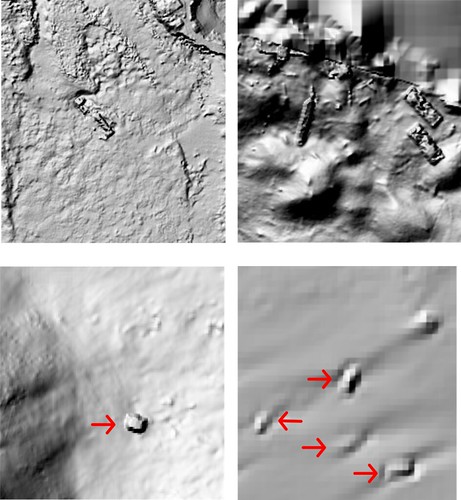
Of these four ocean floor scans, the top two panels clearly show shipwrecks, but the shipwrecks in the bottom two panels, marked by red arrows, could easily be mistaken for natural features. In collaboration with the United States Navy’s Underwater Archaeology Branch, I taught a computer how to recognize shipwrecks on the ocean floor from scans taken by aircraft and ships on the surface. The computer model we created is 92% accurate in finding known shipwrecks. The project focused on the coasts of the mainland U.S. and Puerto Rico. It is now ready to be used to find unknown or unmapped shipwrecks. The first step in creating the shipwreck model was to teach the computer what a shipwreck looks like. It was also important to teach the computer how to tell the difference between wrecks and the topography of the seafloor. To do this, I needed lots of examples of shipwrecks. I also needed to teach the model what the natural ocean floor looks like. Conveniently, the National Oceanic and Atmospheric Administration keeps a public database of shipwrecks. It also has a large public database of different types of imagery collected from around the world, including sonar and lidar imagery of the seafloor. The imagery I used extends to a little over 14 miles (23 kilometers) from the coast and to a depth of 279 feet (85 meters). This imagery contains huge areas with no shipwrecks, as well as the occasional shipwreck. Finding shipwrecks is important for understanding the human past – think trade, migration, war – but underwater archaeology is expensive and dangerous. A model that automatically maps all shipwrecks over a large area can reduce the time and cost needed to look for wrecks, either with underwater drones or human divers. The Navy’s Underwater Archaeology Branch is interested in this work because it could help the unit find unmapped or unknown naval shipwrecks. More broadly, this is a new method in the field of underwater archaeology that can be expanded to look for various types of submerged archaeological features, including buildings, statues and airplanes. This project is the first archaeology-focused model that was built to automatically identify shipwrecks over a large area, in this case the entire coast of the mainland U.S. There are a few related projects that are focused on finding shipwrecks using deep learning and imagery collected by an underwater drone. These projects are able to find a handful of shipwrecks that are in the area immediately surrounding the drone.
To read the complete article, see:
I reached out to our resident shipwreck expert, Bob Evans, the Chief Scientist for S.S. Central America recovery operations. -Editor Bob writes: "This study and the technique is fascinating. But it is restricted to 14 km from the coasts and 85m depth. This corresponds roughly to within "easy" saturation diving access. (Nothing is ever easy. Sat divers are a little weird, but good on 'em! I worked with them on the Brother Jonathan in 2000, so I feel entitled to an opinion.) The SSCA site is well beyond the scope of this study and technique, since it lies roughly 280 km offshore (Cape Fear, NC is the closest point of land) and 2200m down. 150 nautical miles and 7200 feet for those of you keeping the English score, which the English don't anymore. But I digress. For me, the inferential subtext is just how much computer processing technology, ultimately leading to AI, has progressed since those heady days in 1988 when we located and confirmed the SSCA site using a bank of IBM ATs or clones, and C++ as programming. I think that's what we used then. It wasn't "my department." I was just typing. The sonar anomaly of the SSCA site was originally logged, in June 1986, as showing a large geological feature, with human sonar experts making that analysis. We spent 1987 fending off maritime and legal challenges while trying to work on the wrong sites, including one with a lot of coal. Based on the knowledge gained from "ground truthing" those sonar anomalies, my review of the full sonar survey record compelled another look at the "large geological feature," first dive in 1988, and the rest is history. To be sure, there are unknown deposits and features in the deep ocean, 1000-plus meters down, that will still confound and present confusing signals to remote sensing devices and AI, but technology marches on. It will be interesting to see what turns up from this study and its derivatives." I'm looking forward to seeing Bob and all of my old and new numismatic friends at the upcoming ANA show in Rosemont. Bob will be ringing the S.S. Central America ship's bell (part of the site confirmation process in 1988) at scheduled times throughout the show. The sound of history! -Editor

Wayne Homren, Editor The Numismatic Bibliomania Society is a non-profit organization promoting numismatic literature. See our web site at coinbooks.org. To submit items for publication in The E-Sylum, write to the Editor at this address: whomren@gmail.com To subscribe go to: https://my.binhost.com/lists/listinfo/esylum All Rights Reserved. NBS Home Page Contact the NBS webmaster 
|